2007 Texas to Colorado Model T Tour
June 20th thru July 4th, 2007
joining the "Search
for the Mohigans Tour”
and the Model T
Club of Northern Colorado.
|
|
|
|
|
|
|
Since our hotel last night
didn’t have much in the way of food service but did have
kitchenettes, we bought groceries at the City Market and had a
group meal in Jennifer and Ross’s room. This
morning, we did breakfast all together again - fresh fruit,
muffins and breads, cereal. Yum!
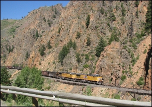
Then we left Granby and headed off
toward Kremmling by way of U.S. Hwy 40 which runs through a
canyon cut by the Colorado River. This is the river that
carves through the Grand Canyon and it actually begins in
Granby. On the other side of the river, perched against
the cliff, was the railroad
|
|
|
|
|
|
|
|
|
|
|
|
tracks. A coal train came through,
fully loaded, and in addition to the two lead engines, it had
four pusher engines in the middle of the train and two on the
end to enable it to climb the mountains in its path.
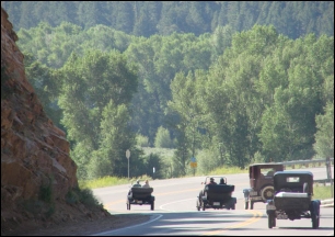
Ben and I had some minor car
trouble coming out of the motel (requiring a new battery) and
Jeff and Blake stayed back to help us. The rest of them
went through the canyon ahead of us and we met up in Kremmling.
This photo of the four Model T’s coming out of the
canyon was taken by our new friend, Patty Duhon.
|
|
|
|
|
|
|
|
|
|
|
|
|
|
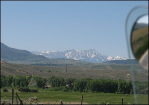
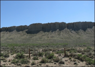
After passing through the canyon, the
scenery leveled out into typical high desert landscape.
Rocky soil, scrub plants (except along the river) and
distant mountains. While we did have some significant
climbs on the trip, they were long slow climbs, not steep.
Every mountain in Colorado has a
name, the peaks all have names, and the ranges that they are
part of all have names. I’m sorry that I
can’t identify many of the mountains in the photographs.
Some are rocky and/or snowy, some are tree-covered, and
some are caprock-bluffs. All of them are beautiful.
After a gas and potty break in Kremmling
(known for its wilderness hunting and fishing camps), we
started off for Rabbit Ears Pass and Steamboat Springs.
These bluffs and the rugged pastures in front of them
have their own kind of beauty. I can’t imagine that
the vegetation can support many cattle, the soil is too rocky
for planting, so you could easily have a thousand acres and
only have 200 useable acres in all. The ranches are huge,
with massive gates and well-maintained fencing. And we
didn’t see very many people.
The T’s easily handled the road and
we only saw a few cars from the tour on the side of the road.
Other drivers help to get them moving again or, if the
problem is too serious to fix roadside, the “vulture
wagon” transports the car and passengers to our next
destination. The parking lots are frequently the scene of
shadetree mechanics and a broken car today is usually running
tomorrow. That is one of the great things about Model
T’s. They are a simple car and easily repaired.
Breakdowns aren’t fun but most drivers, especially
those who come on tours like this one, are pretty good
mechanics.
I was surprised at the number of
lakes we saw. Many were manmade, of course, but some were
natural. It wasn’t until we were selecting photos
for today’s journal that I realized there is a Model T in
the right of this photograph. I don’t know the
driver but he obviously wanted a photo of his car in front of
this lake and doesn’t realize that we got him, too.
One more thing about Model
T’s. If this driver had pulled a Suburban up on
this property, he might have been met by an unfriendly
landowner. Almost everyone loves a Model T and they
usually pull out their cameras and take pictures, too.
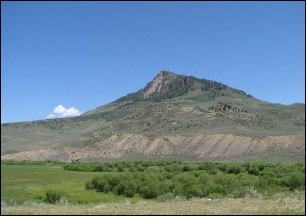
Another photo by Patty. The mountain
in the background is the famous Rabbit Ears Mountain, named for
obvious reasons. I believe that is Luke on the left with
his back to us, Ross in the maroon Fordor, Barbara and Jennifer
Lilleker with Bailey, Bruce Lilleker, Nicky and Austin Bromley
in their car, Martin Thomen in the yellow hat, and Ben and me
in our pickup. This was our first sight of the mountain
and a leadup to the Pass.
Ben and I turned off the highway at
Dumont Lake. Past the picnic and camping areas is a
four-mile, nearly impassable road that leads to a Base Camp for
the Colorado Trail, a hiking trail along the peaks to Rabbit
Ears. The road is still closed for automobile traffic
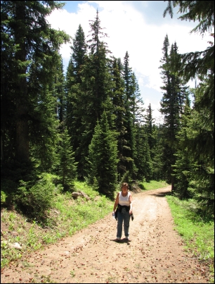
(too early in the season) so we decided to hike up. This
is a personal place for me. Very near the Base Camp is a
memorial to my mother and my sister and I wanted to visit it
again. We’ve hiked up once before but that was a
long time ago and we are a lot older now. Surprisingly,
it was hot! It is a steep climb and I had fallen behind
when Ben took this picture. Marian Rose chased every
butterfly and bug she ran across and had a much easier time
than either of us. It took us 1-1/2 hours to get up and
1-1/2 hours to get down! We never saw another soul until
we almost got back to the parking area and we ran into two
bicyclists who were on their way up. I asked them if they
knew how rough it was and they said, “Oh, yes”
They had ridden up before, just not this year. We
could barely walk and they were riding bikes up! (See the
part about being older, above.)
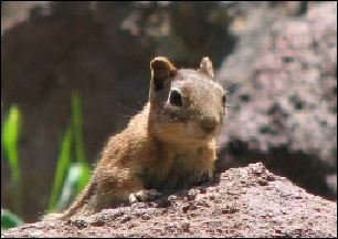
This little fellow darted across the
road in front of us and Marian Rose was sure she could catch
him if we’d just let go of her leash. He climbed up
on the rocks above us and fussed at us for bothering him.
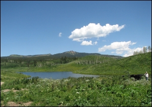
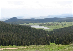
The view from the top of the
mountain makes it almost worth the climb. That is Dumont
Lake you can see in the valley below. Our car is parked
very near the lake, way down there. We’ve been here
before when the entire meadow was filled with wildflowers but
we were a little early this time. There were some lupines
and paintbrush along the road but not many up here above
treeline.
By the way, the road we
climbed runs up the Continental Divide most of the way.
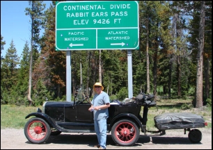
Our tour today crossed the
Continental Divide in two different places. Here you can
see Martin Thomen at the Rabbit Ears Pass crossing, elevation
9426 feet. We also crossed at Muddy Pass, elevation 8772
feet. The highway climbs steadily, criss-crossing its way
to the Pass, then plunges down the other side into Steamboat
Springs. If you have never driven this road, you should!
It is a paved, well-maintained highway. You can do
it in your modern car if you prefer but it is really fun in a
Model T. The views are spectacular no matter what you are
driving.
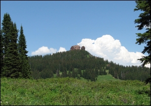
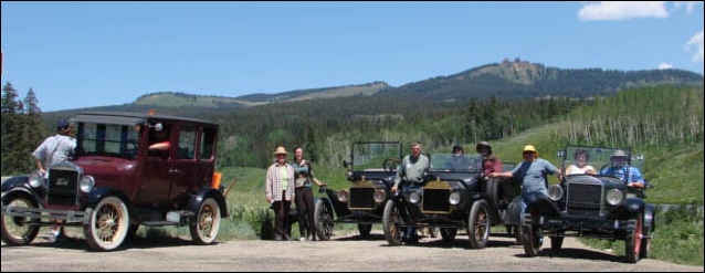
One last photo of Rabbit Ears Mountain.
The sky was really this blue today and the clouds really
this white. It was a perfect drive and the group arrived
into Steamboat around 2:00PM. This gave everyone the
chance to shop, sightsee, and have a good dinner. The
tour planners promoted the idea of a Gondola or balloon ride
but I didn’t hear of anyone who tried it.
Tomorrow, we head out for the
126 mile drive to Saratoga, Wyoming. We plan to take a
differnt route than the official tour to get us off the main
roads. Assuming we get there, I’ll let you know
tomorrow how that worked for us.